

 English
 Bahasa Melayu
Map Orientation and How We Understand al-Ardh
Previously, I deliberately uploaded an infographic without providing any explanation. I asked anyone who wished to leave a comment to do so, whether they understood it or not. I did not mind. I did not expect everyone to understand it straight away. If one or two people could grasp what it meant, I was already grateful. Alhamdulillah.
This time, I am trying to explain it little by little. There is a lot I want to say, but I will explain as much as I can.
I asked AI to produce the infographic because I have noticed that certain images have become ingrained in our minds, even though they may not be entirely accurate or may have led to particular consequences.
The Image of al-Ardh That Is Ingrained in Our Minds
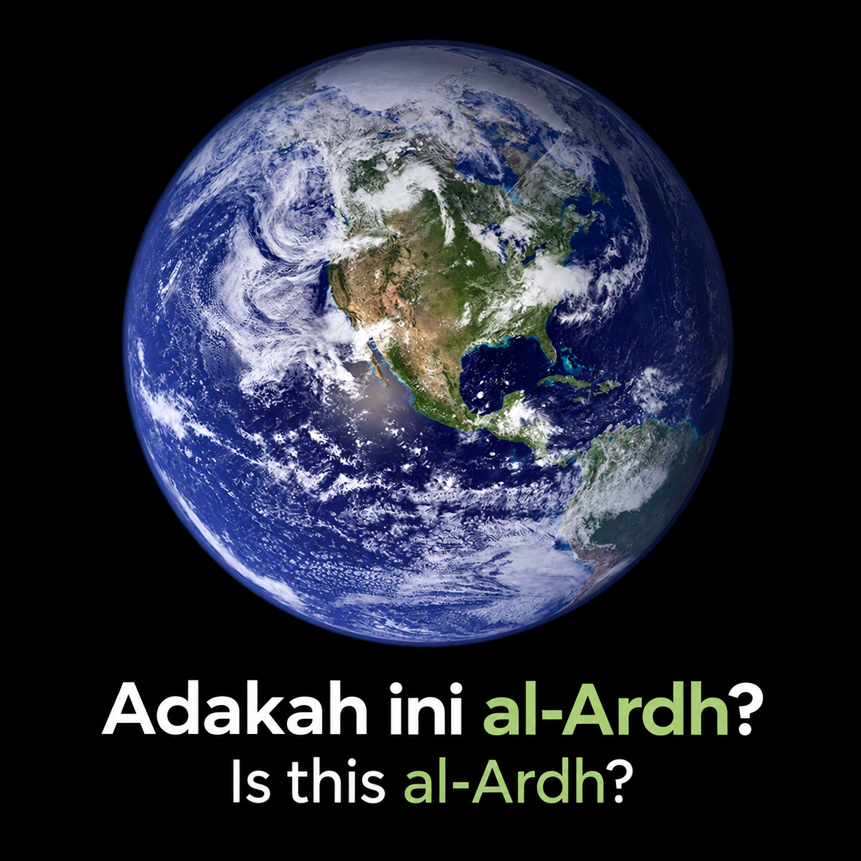
First, let us begin with the word al-Ardh. We understand its translation as “Earth”, do we not? That is the word’s translation. But when the word is mentioned, what image comes to mind?
Usually, we imagine a bluish-white sphere. We see vast oceans, yellowish sandy areas representing deserts and parts covered by thick clouds.
That is the image of Earth that has become embedded in our minds. That is a NASA image, is it not? Recently, NASA also released a new image.
If an image like this were shown to anyone, they might say, “That is Earth.” Some might call it “the planet Earth”. Those more familiar with Arabic terms might call it al-Ardh.
However, within the framework I am presenting here, what we call and imagine is not the same as the image of al-Ardh in the Qur’an.
Al-Ardh refers to land, including islands, that can be walked on and inhabited. The sea, meanwhile, is called al-bahr and is not included in the image of al-Ardh that I mean.
But the image we have stored in our minds is:
Land + water + clouds = Earth = al-Ardh.
Why does this matter? Because images stored in our minds can influence how we think, read the Qur’an and understand it. Our translations and personal interpretations can also be shaped by the framework already established in our minds.
Yet within the framework I am presenting, al-Ardh is not that kind of image.
The World Map Shapes How We Think
The second point is the map.
We are used to seeing a world map that places the East on the right and the American continents on the left. Asia and Africa appear in the middle. The North Pole is at the top and the South Pole at the bottom.
That is the image we have seen for a long time. When we imagine the world laid out flat, this is usually the kind of map that comes to mind.
What are the effects? There are many.
The East and West appear very far apart because they are placed at opposite ends of the map. We also easily get the impression that everything is centred in the middle, as if the entire history of humanity took place there.
The oldest civilisation that usually appears in the general picture is Egypt, followed by Mesopotamia. Both are located in the central region of the map we usually see.
As a result, we also tend to centre the history of the prophets in that region. We build an Arab-centric picture, even though the Arabs are not the most ancient people.
What I want to convey is that the images stored in our minds can change how people think.
Where Are the Traces of the Prophets in Ancient Civilisations?
The third point concerns the traces of the prophets.
We know that there were ancient civilisations in the Americas that were older than, or as old as, Ancient Egypt. But why do we not find traces of the prophets among them in the historical picture we usually study?
Which prophets were sent to the Olmec, Maya, Inca, Red Indians, Hawaiians, Māori and other peoples?
Have we ever thought about this? Did Allah not love them, loving only the people of the Arabian Peninsula?
Does anyone have a theory about this?
How We Imagine Sunrise and Sunset
The next point concerns sunrise and sunset.
An authentic hadith states that after the Sun completes one cycle, it faces its Rabb beneath the Throne and asks whether it should continue on its journey or turn back. In the narration, the Sun returns and rises from the place where it set.
But how do we understand this hadith when the map in our minds places the East on the right and the West on the left?
Usually, we imagine the Sun rising in the East, moving across the sky and then setting in the West. But there is one thing we rarely think about: what happens between sunset and sunrise?
Perhaps we rarely think about it because we are asleep at that time. We also rarely think about it because we may not even wake up for tahajjud and ask ourselves, “Do I ask my Rabb as the Sun asks its Rabb?”
Simply put, we rarely think about this because it does not appear in the familiar image in our minds.
How Map Orientation Changes Our Image of East and West
That is a little of what I wanted to explain before moving on to the main point.
Look at the map on the right side of the infographic. The Pacific Ocean is in the middle, the American continent is on the right and the African continent is on the left.
Imagine that this kind of map had been the familiar image in people’s minds for 2,000 years. What would change? The civilisations of humanity might have been understood and depicted as centred in the Asia-Pacific region. It would have been Asia-Pacific-centric.
In that orientation, when we look towards the Americas, that direction becomes the East, or Mashriq. When we look towards Africa, that direction becomes the West, or Maghrib.
Black Africans would be Westerners. White Americans would be Easterners. People with brown skin would be at the centre of the image of the Earth.
Can you see how images and maps can shape the framework of human thought?
Two Map Orientations and Two Images of History
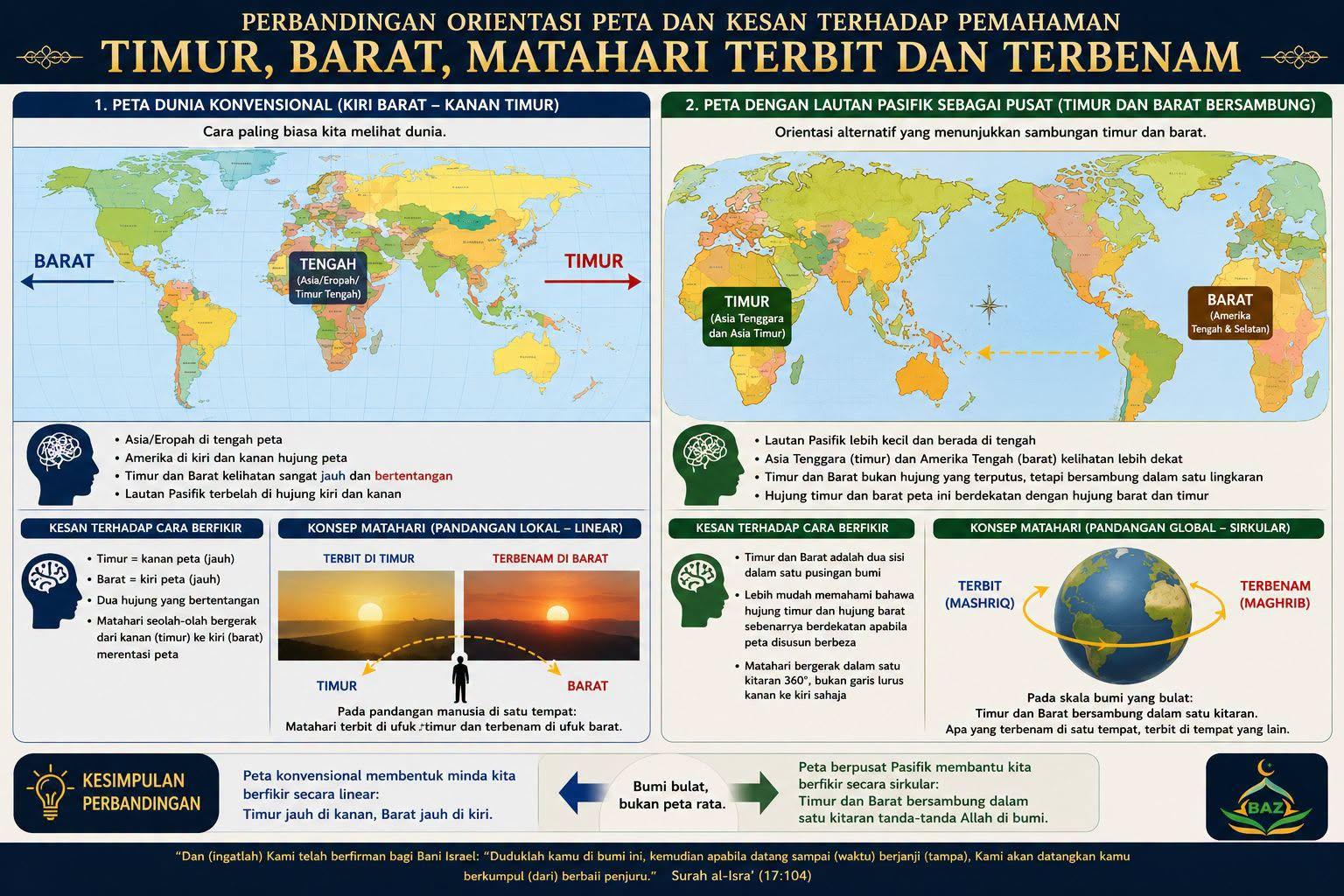
This is the more important issue, and this is why I produced the infographic.
The world map on the left is the map we are using now. How long we will continue using it, I do not know. Allahu a‘lam. Within the framework I am presenting, this is the image of the world that became dominant after the time of Prophet Nuh, after the flood of Prophet Nuh.
The map on the right, meanwhile, depicts the world from the time of Prophet Adam until the time of Prophet Nuh, including the period before the flood during Prophet Nuh’s time.
We find it difficult to imagine the map on the right because it is unfamiliar to us. We could point out the design on the left even with our eyes closed. We may not be able to do the same with the map on the right.
That is one of the difficulties I face when explaining many articles on BAZ, particularly those that use an Anbiya’-centric approach.
It is true that we believe in the prophets. But when we study the history of civilisations, do we use an Anbiya’-centric approach?
We use an Anbiya’-centric approach only when discussing religious matters. But our underlying framework still places almost everything in the Arabian region. That is why I say that, when discussing religion, we often use an Arab-centric approach, not a fully Anbiya’-centric one.
If we want to understand the Qur’an better, we need to use both images of the map, whether the one on the left or the one on the right.
We must also remember that the prophets’ movements extended across al-Ardh. That is why there is al-Masjid al-Haram in Makkah and al-Masjid al-Aqsa in the East. That is why there is Makkah, and that is why there is Bakkah.
Our orientation in understanding the Earth is important when studying the Qur’an. If we explain both orientations, it becomes easier to understand the stories of the earlier prophets and to trace the histories of the peoples mentioned in the Qur’an.
To make this search easier, I have a simple formula. However, it does not apply in every case. The word Ashab or Ashabul usually refers to the right-hand side. The word kaumi refers to the left-hand side. The word Bani can refer to either. This is only a simple formula and does not apply to every case.
When we understand the map on the left, we begin to see why people in the East were so powerful in seafaring. Within the framework I am presenting, this is connected to the era of Prophet Idris, the prophet who brought about a revolution in knowledge.
After that, it is not too difficult to begin understanding matters such as Atlantis, Lemuria, Zealandia, Solomon and similar subjects. The orientation has changed, the image has changed, the framework has changed and the way we think will change as well.
That is all I wanted to say for now. I hope you can understand. It should be easy enough to follow now.
(22.06.2026)
Reply to: